

Two different groups of citizen scientists, staff members from Intrepid Travel and students from Holmesglen TAFE, have joined a team of researchers and land managers from Wadawurrung Traditional Owners Aboriginal Corporation (WTOAC), Arthur Rylah Institute, Parks Victoria and the Blue Carbon Lab for workshops involving weed monitoring in a unique coastal grassland ecosystem. This area is of significant importance to the Wadawurrung people due to its high concentration of cultural heritage sites and artifacts, as well as its historical status as a place of great natural beauty and many useful native species.
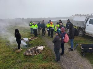
This project focuses on the recovery of a threatened grassland ecosystem through community vegetation surveys that assist with weed monitoring and the creation of weed management strategies for the region. The days began with Corrina, a Wadawurrung Traditional Owner, performing a Welcome to Country and smoking ceremony to welcome the group onto Wadawurrung Country.

Corrina delivered an impactful cultural education session where the group learned about Wadawurrung history and truth-telling, Paleert Tjaara Dja (Let’s make Country good together) and how the group can help, by working together to make Wadawurrung Country and culture strong.
Researchers from Blue Carbon Lab and Arthur Rylah Institute then explained how this project began through the Victorian Coastal Wetland Restoration Program, an overview of the key threats to the site, weed spraying activities that have been happening, and the methods to be used for the vegetation surveys.

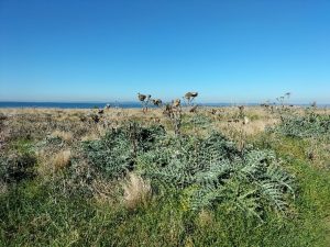
Five sites have been identified at Point Lillias for regular monitoring, each is approximately one hectare in area and contains ten predetermined GPS points at which vegetation assessments are undertaken. The presence, layout (clumped together or scattered) and percentage cover of all high threat weeds within a circle extending out 2 metres from each point are recorded, as well as the percentage cover of any native species present. In some plots native cover was as low as 2%, showcasing the need for weed management strategies. High threat weeds include the usual suspects such as Artichoke Thistle (Cynara cardunculus, left) and Paterson’s Curse (Echium plantagineum), due to their dominance over resources and ability to out-compete native species, as well as other introduced species such as Wild Oat (Avena spp.). This weed has been considered high threat due to its cultural implications, as its dominating stature when fully grown particularly represents colonisation to Wadawurrung people.

Photos of each overall hectare site as well as general observations of weed species presence and composition are also noted. These observations help us identify how prominent different weed species are, where they are distributed and how this changes over time in order to effectively come up with strategies to decrease their prevalence and promote native species growth. These sites are assessed four times a year to account for seasonal variation in weed and native plant life cycles. The first monitoring workshop with staff from Intrepid Travel was in autumn (May 3rd, 2022), while the winter monitoring workshop occurred last week (July 21, 2022) with students from Holmesglen TAFE. Two more citizen science workshops are planned for spring and summer later in the year. Please e-mail Dr Noyan Yilmaz (noyan.yilmaz@deakin.edu.au) if you are interested in joining.

Despite freezing temperatures and a thick fog that didn’t clear until midday, groups of students led by researchers were able to complete observations of all five sites for the winter monitoring. This data, along with future monitoring efforts, will prove invaluable to weed management and native species restoration efforts going forward.